New Draft Moreton Bay Regional Planning Scheme is now available for scrutiny (albeit briefly)
Not that you'd necessarily know it but the new Moreton Bay Regional Council Planning Scheme is now available for scrutiny.
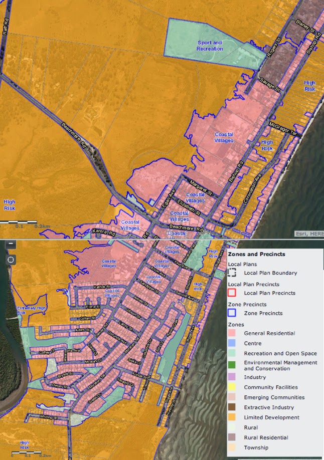
You have to go here to the draft mapping to gather the zone-ing layout, then zoom in big time to focus on the Beachmere region. Only by getting up real close to the map do you get the detail.
Use the + symbol to get in close.
The Council’s draft planning scheme is on public display until August 15th.Use the + symbol to get in close.
Did you know that?
- Limited Development Zone: comprises land known to be affected by unacceptable flood, storm tide or erosion risk. A small range of uses are expected in the zone, including: outdoor sport and recreation permanent plantation park. All land in the Limited development (constrained land) zone is contained in 1 of 2 precincts with the following intent: Extremely high risk precinct - prevent any further development including the replacement of any structure or building. High risk precinct - limit the intensification of uses, but allow replacement of existing structures.
- The term 'coastal village' which covers much of the Beachmere residential area is not directly defined but a table suggests its allowed occupancy:

Anyone who has more information about this scheme i s encouraged to add further detail in Comments below. If you do please also include any links and references to back up your assertions.
Any hearsay will be disallowed and deleted.
Update: July 22:
The current zoning map is here... I think -- and I have linked to the tide maps on the top page of this blog for some time. That link: Tide maps.